 All Giza Pyramids in one shot. Credit Wikimedia / Ricardo Liberato – All Gizah Pyramids
Scientists discovered that the Egyptian pyramids were built along a now-defunct branch of the Nile River.
The research team led by Eman Ghoneim from the University of North Carolina Wilmington underscored the river’s historical importance and the impact of environmental changes on human civilization. This study, published in Communications Earth & Environment, helps explain why the pyramids are located in what is now a desolate part of the Saharan Desert.
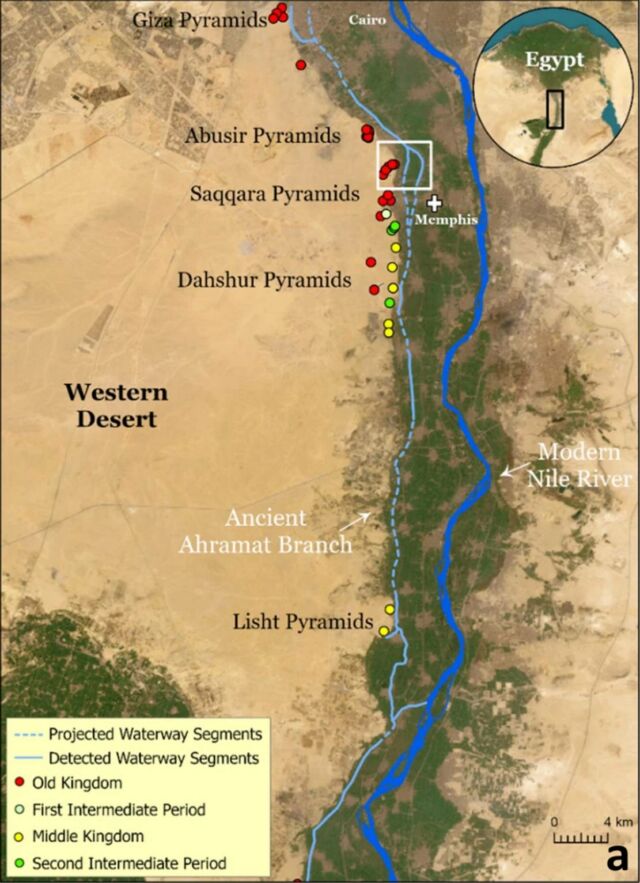
The research focused on the pyramid fields between Giza and Lisht, constructed over a millennium around 4,700 years ago, on the edge of the Western Desert. Sediment analysis indicates that the Nile once had a higher flow, with multiple branches, one of which likely passed by the pyramids. Ghoneim’s team used satellite images, geophysical surveys, and sediment samples to confirm this branch’s location, which they propose naming Ahramat, Arabic for pyramids. They suggest that increased windblown sand from a major drought about 4,200 years ago caused the branch to shift east and eventually dry up.
 A map showing the proposed site of the newly discovered branch of the Nile. Eman Ghoneim et al.
This research was funded by a grant from the National Science Foundation awarded to Ghoneim, University of Memphis Associate Professor Suzanne Onstine, and Macquarie University Associate Professor Tim Ralph.
Eman Ghoneim, said:
“Many of us who are interested in ancient Egypt are aware that the Egyptians must have used a waterway to build their enormous monuments, like the pyramids and valley temples, but nobody was certain of the location, the shape, the size, or proximity of this mega waterway to the actual pyramids site. Our research offers the first map of one of the main ancient branches of the Nile at such a large scale and links it with the largest pyramid fields of Egypt.”
source University of North Carolina Wilmington


Leave A Comment