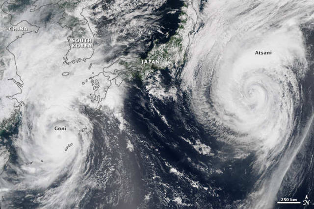
The ninth and tenth typhoons of the year spun in the vicinity of Japan, in August 2015, as you can see in this VIIRS satellite image.
This natural-color image mosaic is based on data collected during two orbital passes of the Visible Infrared Imaging Radiometer Suite (VIIRS) on Suomi NPP. The instrument captured Typhoon Goni, visible to the west, at 0410 Universal Time (1:10 p.m. local time) on August 24, 2015. It captured Typhoon Atsani, visible to the east, less than two hours earlier at 0230 Universal Time (11:30 a.m. local time).
Typhoons in the western North Pacific can happen at any time of year, but activity tends to pick up during the summer months.
A tropical cyclone is called a typhoon if the storm is located in the Northwest Pacific Ocean—west of the dateline—and has maximum sustained winds of at least 119 kilometers per hour (74 miles per hour). When this image was acquired, Typhoon Goni was a Category 3 storm with maximum sustained winds of 204 kilometers (127 miles) per hour; Typhoon Atsani was a Category 1 storm with winds measuring 120 kilometers (75 miles) per hour, according to UNISYS.
NASA Earth Observatory image by Jesse Allen, using VIIRS data from the Suomi National Polar-orbiting Partnership. Suomi NPP is the result of a partnership between NASA, the National Oceanic and Atmospheric Administration, and the Department of Defense. Caption by Kathryn Hansen.
source earthobservatory


Leave A Comment