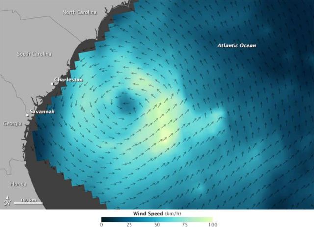
Ana is the first tropical storm of the North Atlantic hurricane season, in mid-May 2015. The storm made landfall along the Carolina coast, on May 10 and carried maximum sustained winds of 74 kilometers per hour (46 miles per hour).
May is early to see large storms in the Atlantic; the season begins in earnest on June 1.
Scientists took the opportunity to observe Ana’s wind dynamics with the International Space Station-Rapid Scatterometer (ISS-RapidScat). The instrument, which joined NASA’s Earth observing fleet in September 2015, measures ocean surface wind speed and direction from orbit on the International Space Station.
The image above was produced with data acquired by RapidScat as Ana approached the coast on the afternoon of May 8, 2015. Arrows represent the direction of near-surface winds. Shades of blue indicate the range of wind speeds (lighter blue and green represent faster-moving winds). The image below, acquired with the Moderate Resolution Imaging Spectroradiometer (MODIS) on NASA’s Terra satellite, shows a natural-color view of the same storm as it appeared on the morning of May 9.
NASA Earth Observatory map (top) by Joshua Stevens using RapidScat data from the Jet Propulsion Laboratory. NASA image (bottom) by Jeff Schmaltz, LANCE/EOSDIS Rapid Response. Caption by Kathryn Hansen.
source Earthobservatory


Leave A Comment