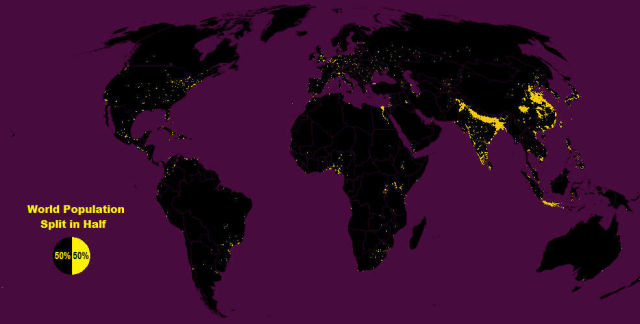
Half the world’s 7.3 billion people are living in this tiny yellow marked part on the map above and the rest are spread across that vast area in black!
New York-based Max Galka, using gridded population data published by NASA, recorded the global population in this simple world map.
The yellow part is only covering the 1% of the world’s land!
The map above based on a population grid of 28 million cells, that each one measuring 3 miles x 3 miles. Max Galka explains:
- “The yellow region in the map includes every cell with a population of 8,000 or more people. Since each of them has an area of about 9 square miles (14 square km), the population density of each yellow cell is at least 900 people per square mile (1.6 km), roughly the same population density as the state of Massachusetts.
- Conversely, the black region is made up of those cells with populations of less than 8,000 people. In other terms, the population density throughout the black area is less than 900 people per square mile.”
You can download a high resolution version of the map, here.
source Max Galka

Leave A Comment