This week, two Pacific storms are lining up to hit the island of Hawaii, which rarely takes a direct hit from a hurricane.
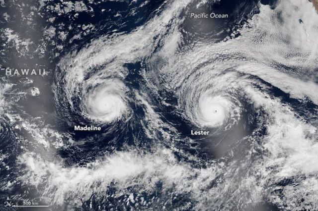
The natural-color image above is a composite built from two overpasses by the Visible Infrared Imaging Radiometer Suite (VIIRS) on the Suomi NPP satellite on August 29, 2016. At the time, Hurricane Madeline and Hurricane Lester were both hovering between category 3 and 4 storms. The bright streaks across the ocean surface (crossing Hawaii and Lester) are areas of sunglint, where sunlight reflected directly back at the VIIRS imager.
At 11 a.m. Hawaii Standard Time on August 30, Madeline was centered 370 miles east-southeast of Hilo, Hawaii, and had sustained wind speeds of 115 miles (185 kilometers) per hour. At the same time, Lester’s wind speed was 120 mph (195 kmph) and its position was 1,300 miles east of Hilo.
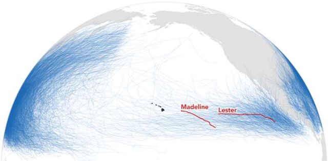
The map below shows the tracks of Madeline and Lester compared to the tracks of all reported storms in the National Oceanic and Atmospheric Administration record from 1842 to 2016. Note the relative lack of storms in the central Pacific compared to the waters off Central America and Asia.
source earthobservatory



Leave A Comment