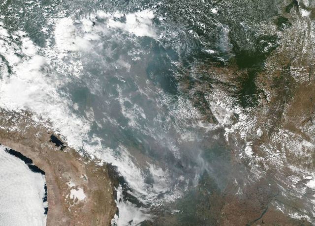
A natural-color satellite image of wildfires in the Brazilian Rainforest, creating cross country smoke in several states within Brazil including Amazonas, Mato Grosso, and Rondônia.
The image was collected by NOAA/NASA’s Suomi NPP using the VIIRS (Visible Infrared Imaging Radiometer Suite) instrument on August 20, 2019. It is not unusual to see fires in Brazil at this time of year due to high temperatures and low humidity. Time will tell if this year is a record breaking or just within normal limits.
NASA’s Earth Observing System Data and Information System (EOSDIS) Worldview application provides the capability to interactively browse over 700 global, full-resolution satellite imagery layers and then download the underlying data. Many of the available imagery layers are updated within three hours of observation, essentially showing the entire Earth as it looks “right now.” Suomi NPP is managed by NASA and NOAA. Image Courtesy: NASA Worldview, Earth Observing System Data and Information System (EOSDIS). Caption: Lynn Jenner, Editor: Lynn Jenner
The fires, which have increased by 83% since 2018, have caused massive devastation and sparked concerns that the blazes could accelerate climate change.
Latest #Copernicus Atmosphere Monitoring Service aerosol forecast shows smoke from widespread fires in Amazonia reaching Atlantic coast & Sao Paolo, following increased fire activity especially in states of Amazonas & Rondonia since 1 August in GFAS data.
Aerosol Optical Thickness Updating Forecast. The atmosphere is made up of gases like oxygen, nitrogen, and water vapor, but it also contains tiny particles called aerosols. Aerosols come from both natural and human sources and include things like sea salt, dust, soot, and sulfates.


Leave A Comment